"Sine City" - San Marcos Creek Development Project
|
|
The "Sine City" project is creatively designed to incorporate trigonometry to a modern day, real life development plan in San Marcos, California. The plan is called The San Marcos Creek Development and is an effort made by the city to create a downtown for San Marcos. The area to be gentrified is approximately 214 acres and has been developed based on an extensive analysis of environmental conditions and the general public of the community, taking into account certain development standards. The objective of our "Sine City" project was to plan and design buildings that meet these standards and that could hypothetically be used as real plans for the development.
We began this project with an introduction to trigonometry, focusing on concepts like the Pythagorean theorem, law of sine, law of cosine, etc... We also did some research on the San Marcos Creek Specific Plan which describes, in detail, the requirements and standards for each plot of land as well as general land use protocol. When we finished the unit, we applied our knowledge by going on a site visit to see the actual plot of land that was to be developed. While we were there, we were looking for specific features on the land such as natural features, man-made features and aesthetic factors and used trigonometry to find angles and heights of trees and slopes to get a good 3-D sketch of our plot of land. We used this information to create a site analysis, determining what should be considered when designing our building and what needed to be done to the land before it's ready for construction.
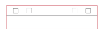
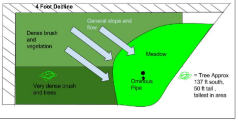
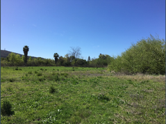
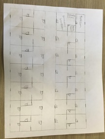
My group was assigned plot 2 which is 107 meters by 99 meters and is near the corner of San Marcos Boulevard and Discovery. In our site analysis, we concluded that our plot of land was too overgrown with thick brush and there was an ominous pipe in the middle which required inspection and possible extraction. Once we knew what we were dealing with, we had to research what kind of establishments the city planned on incorporating in their downtown. The requirements stated in the Specific Plan for our plot of land says it's meant to be a residential, commercial area. so we designed our buildings to have retail stores and businesses on the lower level and residential living on the upper level. Then we started to create preliminary hand drawn sketches of our buildings. We had to create sketches of the buildings from different views like a site view, a floor plan, and four elevation views for the north, south, east and west sides. I was originally going to do the floor plan (left) for the top floor of our building, but after some dispute with a group mate, we decided the scale was off, so I wound up doing the east and west elevation views instead. After the hand drawn sketches were critiqued and finalized, we used Adobe Illustrator to create a digital, to scale blueprint for the mini model of our buildings. The plans were then used to laser cut pieces of wood into our little buildings. The east and west elevation view is below and are the same because the building is symmetrical.
We began this project with an introduction to trigonometry, focusing on concepts like the Pythagorean theorem, law of sine, law of cosine, etc... We also did some research on the San Marcos Creek Specific Plan which describes, in detail, the requirements and standards for each plot of land as well as general land use protocol. When we finished the unit, we applied our knowledge by going on a site visit to see the actual plot of land that was to be developed. While we were there, we were looking for specific features on the land such as natural features, man-made features and aesthetic factors and used trigonometry to find angles and heights of trees and slopes to get a good 3-D sketch of our plot of land. We used this information to create a site analysis, determining what should be considered when designing our building and what needed to be done to the land before it's ready for construction.
My group was assigned plot 2 which is 107 meters by 99 meters and is near the corner of San Marcos Boulevard and Discovery. In our site analysis, we concluded that our plot of land was too overgrown with thick brush and there was an ominous pipe in the middle which required inspection and possible extraction. Once we knew what we were dealing with, we had to research what kind of establishments the city planned on incorporating in their downtown. The requirements stated in the Specific Plan for our plot of land says it's meant to be a residential, commercial area. so we designed our buildings to have retail stores and businesses on the lower level and residential living on the upper level. Then we started to create preliminary hand drawn sketches of our buildings. We had to create sketches of the buildings from different views like a site view, a floor plan, and four elevation views for the north, south, east and west sides. I was originally going to do the floor plan (left) for the top floor of our building, but after some dispute with a group mate, we decided the scale was off, so I wound up doing the east and west elevation views instead. After the hand drawn sketches were critiqued and finalized, we used Adobe Illustrator to create a digital, to scale blueprint for the mini model of our buildings. The plans were then used to laser cut pieces of wood into our little buildings. The east and west elevation view is below and are the same because the building is symmetrical.